


TAMALCO 1 Voting District, Bond County, Illinois
About
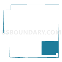
Outline

Summary
| Unique Area Identifier | 564565 |
| Name | TAMALCO 1 Voting District |
| County | Bond County |
| State | Illinois |
| Area (square miles) | 30.96 |
| Land Area (square miles) | 30.87 |
| Water Area (square miles) | 0.09 |
| % of Land Area | 99.71 |
| % of Water Area | 0.29 |
| Latitude of the Internal Point | 38.79201590 |
| Longtitude of the Internal Point | -89.31661720 |
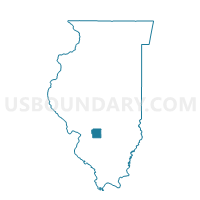
Maps

Graphs
Select a template below for downloading or customizing gragh for TAMALCO 1 Voting District, Bond County, Illinois


Neighbors
Neighoring Voting District (by Name) Neighboring Voting District on the Map
- CENTRAL 5 Voting District, Bond County, IL
- MILLS Voting District, Bond County, IL
- PLEASANT MOUND 1 Voting District, Bond County, IL
- PLEASANT MOUND 2 Voting District, Bond County, IL
- SEMINARY 1 Voting District, Fayette County, IL
- TAMALCO 2 Voting District, Bond County, IL
Top 10 Neighboring County Subdivision (by Population) Neighboring County Subdivision on the Map
- Central township, Bond County, IL (8,013)
- Pleasant Mound township, Bond County, IL (1,018)
- Tamalco township, Bond County, IL (566)
- Mills township, Bond County, IL (552)
- Seminary township, Fayette County, IL (498)
Top 10 Neighboring Unified School District (by Population) Neighboring Unified School District on the Map
- Bond County Community Unit School District 2, IL (13,592)
- Carlyle Community Unit School District 1, IL (10,196)
- Mulberry Grove Community Unit School District 1, IL (2,507)